Tamilnadu State Board New Syllabus Samacheer Kalvi 7th Social Science Guide Pdf Geography Term 1 Chapter 2 Landforms Text Book Back Questions and Answers, Notes.
Tamilnadu Samacheer Kalvi 7th Social Science Solutions Geography Term 1 Chapter 2 Landforms
7th Social Science Guide Landforms Text Book Back Questions and Answers
I. Choose the correct answer:
Question 1.
…………………… is a deposition of river sediments along the foot-hills.
a) Plung pool
b) Alluvial fan
c) Flood plain
d) Delta
Answer:
b) Alluvial fan
![]()
Question 2.
Courtallam falls is located across the ………………………….river.
a) Cauvery
b) Pennar
c) Chittar
d) Vaigai
Answer:
c) Chittar
Question 3.
The landform created by glacial deposition is …………..
a) Cirque
b) Arete
c) Moraine
d) Tam lake
Answer:
c) Moraine
Question 4.
Large deposits of loess are found in …………..
a) the USA
b) India
c) China
d) Brazil
Answer:
c) China
![]()
Question 5.
Landform which is not associated with wave erosion
a) Cliffs
b) Sea arch
c) Stacks
d) Beaches
Answer:
d) Beaches
II. Fill in the blanks:
1. The process of breaking and crumbling of rocks is ………………………….
Answer:
weathering
2. The place where the river joins a lake or a sea is known as ………………………….
Answer:
River mouth
3. Inselbergs are found in the …………………………. desert in South Africa.
Answer:
Kalahari
4. A cirque is known as ………………………….in Germany.
Answer:
Kar
![]()
5. The longest beach in the world is ………………………….
Answer:
Miami Beach in the U.S.A
III. Match the following:
| 1. Breaking and crumbling of rocks | a) Glacier |
| 2. Abandoned meander loops | b) Barchans |
| 3. Large body of moving ice | c) Lagoon |
| 4. Crescent-shaped sand dunes | d) Weathering |
| 5.Vembanad lake | e) Oxbow lake |
Answer:
| 1. Breaking and crumbling of rocks | d) Weathering |
| 2. Abandoned meander loops | e) Oxbow lake |
| 3. Large body of moving ice | a) Glacier |
| 4. Crescent-shaped sand dunes | b) Barchan |
| 5.Vembanad lake | c) Lagoon |
IV. Consider the following statement and tick (✓) the appropriate answer:
Question 1.
Assertion (A): The deltas are formed near the mouth of the river.
Reason (R): The velocity of the river becomes slow when it approaches the sea.
a) Both A and R are correct
b) A is correct and R is wrong
c) A is wrong and R is correct
d) Both A and R are wrong
Answer:
a) Both A and R are correct
![]()
Question 2.
Assertion (A) : Sea arches in turn become Sea Stacks.
Reason (R) : Sea Stacks are the results of wave deposition,
a) Both A and R are correct
b) A is correct and R is wrong
c) A is wrong and R is correct
d) Both A and R are wrong
Answer:
b) A is correct and R is wrong
V. Answer the following:
Question 1.
Define erosion.
Answer:
Erosion is the wearing away of the landscape by water, wind, ice and sea waves, etc.
![]()
Question 2.
What is a plunge pool?
Answer:
The plunge pool is a hollow feature at the base of a waterfall formed by cavitation.
Question 3.
How are Oxbow lakes formed?
Answer:
Due to continuous erosion and deposition, the meander loop cuts off from the river and forms a cut-off lake is called an Ox-bow lake.
Question 4.
Name the major landforms formed by glacial erosion.
Answer:
Mountain or valley Glacier, cirque, Tam Lake, Arets, TJ’ shaped Valley.
Question 5.
Give a note on Mushroom rocks.
Answer:
In deserts, the rocks in the shape of a mushroom are commonly called mushroom rocks.
![]()
Question 6.
What is a lagoon? Give an example.
Answer:
- A lagoon is a shallow stretch of water partially or completely separated from the sea.
- Ex: Chilkalake, Pulikat lake, and Vembad lake.
VI. Distinguish the following:
Question 1.
Tributary and Distributary
Answer:
Tributary: A Stream or river that flows into and joins the main river.
Distributary: A stream that branches off and flows away from the mainstream.
Question 2.
‘V’ shaped valley and ‘U’ shaped valley
Answer:
‘V’ Shaped Valley
- formed by the river erosion.
- The landscape creates a steep-sided valley like the letter ‘V’ is ‘V’ shaped valley.
![]()
‘U’Shaped Valley:
- formed by Glacier erosion.
- The landscape deepened and widened by the lateral and vertical erosion is like a letter TJ’ is TJ1 shaped valley.
Question 3.
Continental glacier and Mountain glacier
Answer:
Continental Glacier:
- The Glacier covering vast areas of a continent with thick ice sheets.
- Ex: Antarctica, Greenland
Mountain Glacier:
- Mountain Glacier is a stream of ice flowing along a valley and bounded by steep sides.
- Ex: The Himalayas and the Alps
VII. Give Reason:
Question 1.
The ends of the meander loops come closer and closer.
Answer:
Due to continuous erosion and deposition of rivers along the sides of the meander, the ends of the meander loop comes closer and closer.
Question 2.
Flood plains are very fertile.
Answer:
- As the river floods, it deposits layers of fine soil and other materials called sediments along its banks.
- This leads to the formation of a flat fertile flood plain. So the flood plains are very fertile.
![]()
Question 3.
Sea caves are turned into stacks.
Answer:
As the cavities of sea caves become bigger, only the roof of the caves remains to form sea Arches. When erosion further breaks the roof, only walls are left, thus forming stacks.
VIII. Answer in a paragraph:
Question 1.
Explain different landforms produced by river erosion.
Answer:
The running water in the river erodes the landscape and formed different kinds of land. They are:
- ’V’Shaped Valley: The river erosion creates a steep-sided valley like the letter ‘V’ is known as ‘V’ Shaped Valley.
- Waterfall: When the soft rocks are removed by river erosion formed a waterfall. E.g: Courtallam falls
- Plunge Pool: It is a hollow feature at the base of a waterfall which is formed by cavitation.
- Oxbow lake: Due to continuous erosion along the sides of the meander, the loop cuts off from the river and forms a cutoff lake is called Oxbow lake.
![]()
Question 2.
Describe the landforms associated with wind.
Answer:
By the wind, erosion, and deposition the different types of land formed.
Mushroom Rocks:
In deserts, the rocks in the shape of Mushroom commonly called Mushroom Rocks.
Inselbergs:
The eroded hill standing like a pillar with rounded tops are called Inselbergs.
Sand Dunes:
As the wind blows the sand transformed and deposited in low hill like structures called sand Dunes.
Barchans.
The crescent-shaped sand dunes are called Barchans.
Loess:
Very fine and light sand is deposited in large areas is called Loess.
![]()
Question 3.
How are aretes formed?
Answer:
- When two adjacent cirques erode towards each other, the previously rounded landscape is transformed into narrow rocky, steep-sided ridges called Aretes.
- Thus by the erosion of Glacier, the Aretes are formed.
Activity:
Question 1.
Fill in the corresponding columns with reference to the landform feature given below:
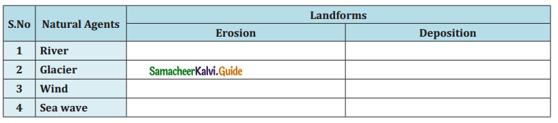 Answer:
| S.No | Natural Agents | Landforms | |
| Erosion | Deposition | ||
| 1. | River | V-Shaped Valley | Alluvial Fan |
| 2. | Glacier | Arete | Moraine |
| 3. | Wind | nselberg | Barchan |
| 4. | Sea wave | Cliff | Lagoon |
[Barchan, ‘V’ Shaped valley, Cliff, Arete, Inselberg, Moraine, Alluvial fan, Lagon]
![]()
Question 2.
Identify any one of the following features near your home town and write a note on them.
Answer:
- Hill – The rocks, mountains are known as hills. The rivers originate from hills.
- Waterfall – The falling of water over a vertical step in the river bed is called a waterfall.
- River (or) stream – The water flowing in a definite course is called a river or stream.
- Beach – The sea waves deposit sediments of sand and gravel along shores forming beaches.
Activity:
Find out the names of a few rivers of the world that form a delta with the help of the Atlas.
- Amazon Delta
- Danube Delta
- Ebro Delta
- Fly Delta
- Ganges-Brahmaputra Delta
- Godavari Delta
- Irrawaddy Delta
- Indus River Delta
- Nile Delta
- Yellow River Delta.
7th Social Science Guide Landforms Additional Important Questions and Answers
I. Choose the Correct answer:
Question 1.
The place of the origin of the river is ………………..
a) Source
b) mouth
c) Lake
d) delta
Answer:
a) Source
![]()
Question 2.
The highest waterfalls in South America is
a) Niagara
b)joke
c) Angel
d)Kuttralam
Answer:
c) Angel
Question 3.
………………..falls is located on the border between Canada and U.S.A.
a) Jake
b) Niagara
c) Angel
d) contra lame
Answer:
b) Niagara
Question 4.
Victoria Falls located in which continent
a) Bengal
b) pern
c) Asia minor
d) Africa
Answer:
Africa
![]()
Question 5.
Meander River flows in
a) Bengal
b) Peru
c) Asia minor
d) England
Answer: Asia minor
Question 6.
Corride cirque is located in
a) Holland
b) Scotland
c) Iceland
d) New Zealand
Answer:
Scotland
![]()
Question 7.
The crescent shaped sand dunes are called
a) Barchens
b) Meander
c) Lagoon
d) delta
Answer:
a) Barchens
Question 8.
The collection of sediments from all the mouths of river forms
a) Lagoons
b) delta
c) Meander
d) Valley
Answer: delta
Question 9.
The largest beach in the world is ………………..
a) Marina
b) vembanad
c) Silica
d) Miami
Answer:
d) Miami
![]()
Question 10.
A shallow stretch of water partially separated from the sea is
a) Lagoon
b) delta
c) Meander
d) Barchens
Answer:
a) lagoon
II. Fill in the blanks:
1. Rivers generally originate from a ……………….. or ………………..
Answer:
mountain, hill
![]()
2. The raised river banks are called ………………..
Answer:
Levees
3. An active agent of erosion and deposition in the deserts is ………………..
Answer:
wind
4. An isolated residual hill, stand like a pillar with rounded tops are ………………..
Answer:
Inselbergs
5. Northern China loess deposits are brought from the ……………….. Desert.
Answer:
Gobi
6. A part of land adjoining near the sea is called ………………..
Answer:
sea coast
![]()
7. The boundary of the sea coast, where land meets water is ………………..
Answer:
coastline
8. ………………..are steep rockfaces formed when the sea waves dash against them.
Answer:
sea cliffs
9. The wall-like feature in the sea is ………………..
Answer:
stacks
10. The second largest beach in the world is the ……………….. beach in Chennai.
Answer:
Marina
11. Moraines are ………………..deposition.
Answer:
glacial
12. ……………….is a stream or river that flow into and joins the main river.
Answer:
Tributary
![]()
13. The collection of sediments from all the months of river forms ………………..
Answer:
Delta
14. ………………..is the armchair shaped depression formed by glacial erosion.
Answer:
Cirque
15. The process of leveling of highlands is called ………………..
Answer:
Gradation
![]()
III. Match the following.
| 1. | Meander River | a) Antarctica |
| 2. | Valley Glacier | b) River curves |
| 3. | Contimental Glacier | c) Corrie cirque |
| 4. | Scotland | d) Alps mountain |
Answer:
| 1. | Meander River | b) River curves |
| 2. | Valley Glacier | d) Alps mountain |
| 3. | Continental Glacier | a) Antarctica |
| 4. | Scotland | c) Corrie cirque |
IV. Consider the following statement and tick (✓) the appropriate answer:
Question 1.
Assertion (A) : The coastal areas are subject to change.
Reason (R) : Wave erosion and wave deposition frequently happened on sea coasts
a) A and R are correct explanations of A
b) A and R are correct but A does not explain R
c) A is incorrect but R is correct
d) Both A and R are incorrect
Answer:
a) A and R are correct explanations of A
![]()
Question 2.
Assertion (A) : Sand is deposited in large areas is called loess
Reason (R) : The wind can carry the sand are very long distances
a) A and R are correct explanations of A
b) A and R are correct but A does not explain R
c) A is incorrect but R is correct
d) Both A and R are correct
Answer:
d) Both A and R are correct
V. Answer the following:
Question 1.
Define River.
Answer:
The water flowing from its source to the river mouth, along a definite course is called River.
Question 2.
How waterfalls are formed?
Answer:
- The falling of river water over a vertical step in the river bed is called a waterfall. It is formed when the soft rocks are removed by erosion.
- E.g. courtallam falls.
![]()
Question 3.
Bring out the feature of Meanders with examples.
Answer:
- As the river enters the plain it twists and turns to form large bends known as Meanders.
- E.g. Meanders along the River Vellar in Tamil Nadu.
Question 4.
Define Glacier.
Answer:
A large body of ice moving slowly down a slope or valley due to gravity is called Glacier.
Question 5.
What is inselberg?
Answer:
- An isolated residual hill, standing like a pillar with rounded tops are called Inselbergs.
- E.g. Inselberg in the Kalahari Desert.
Question 6.
What is a Sand bar?
Answer:
Sandbar is an elongated deposition of sand or mud found in the sea, parallel to the coast.
![]()
VIII. Answer in a paragraph:
Question 1.
What are the forces of landforms – Explain.
Answer:
There are two processes in the force of landforms.
- The endogenic process (internal): The endogenic process leads to the upliftment and sinking of the earth’s surface at several places.
- The exogenic process (external): The Exogenic process is the continuous wearing down and rebuilding of the land surface.
Question 2.
Describe Delta.
Answer:
- Each River distributary forms its own mouth.
- The collection of sediments from all the mouths form Delta.
- Deltas are excellent productive lands. They have more minerals which favours cultivation.
- Eg: Cauvery Delta, Ganga Delta.
![]()
Question 3.
How sea caves are formed?
Answer:
- Sea waves continuously strike at the rocks. Cracks develop.
- Over time they become larger and wider. Thus, hollow like caves are formed on the rocks in the sea.
- Thus, sea caves are formed.