Tamilnadu State Board New Syllabus Samacheer Kalvi 9th Social Science Guide Pdf Civics Chapter 3 Human Rights Text Book Back Questions and Answers, Important Questions, Notes.
Tamilnadu Samacheer Kalvi 9th Social Science Solutions Civics Chapter 3 Human Rights
Samacheer Kalvi 9th Social Science Human Rights Text Book Back Questions and Answers
I. Choose the correct answer
Question 1.
Apartheid’was followed by ____________
(a) South Sudan
(b) South Africa
(c) Nigeria
(d) Egypt
Answer:
(b) South Africa
Question 2.
____________ right exercises in the formation and administration of a government.
(a) Social
(b) Economic
(c) Political
(d) Cultural
Answer:
(c) Political
![]()
Question 3.
A 10 year old boy is working in a shop. Which right can you use to recover him?
(a) Right to equality
(b) Right to freedom
(c) Right against child labour exploitation
(d) Right to freedom of Religion
Answer:
(c) Right against child labour exploitation
Question 4.
What is the time limit to get the information from RTI Act 2005?
(a) 20 days
(b) 25 days
(c) 30 days
(d) 35 days
Answer:
(c) 30 days
Question 5.
Which of the following statements are true?
(i) The state Human Rights commission was established in 1993.
(ii) It has the power of a civil court.
(iii) It’s power extend beyond the state.
(iv) It can also recommend compensation to victims.
(a) i and ii are true
(b) i and iii are true
(c) i, ii and iii are true
(d) ii, iii and iv are true
Answer:
(ii), (ii) and (iv) are true
![]()
Question 6.
Consider the following statements.
Assertions (A): Rights and duties are the two sides of the same coin.
Reason (R): We have a right to freedom of religions. We have to promote harmony and
the spirit of the people of other religions.
(a) Both A and R are correct and R explains A
(b) Both A and R are correct but R does not explain A
(c) A is correct but R is false
(d) A is false but R is correct
Answer:
(a) Both A and R are correct and R explains A
Question 7.
According to the UNO, a child is a person who has not completed the age of ________ years
(a) 12
(b) 14
(c) 16
(d) 18
Answer:
(d) 18
![]()
Question 8.
Kailasta Satyarthi and Malala have been awarded Nobel Prize for ____________
(a) Literature
(b) Peace
(c) Physics
(d) Economics
Answer:
(b) Peace
II. Fill in the blanks
- The Universal Declaration of Human Rights Contains ____________ articles.
- The fundamental Duties were incorporated in the Constitution by ____________ Amendment Act.
- The National Human Rights commission was established on ____________
- Indian state to implement women ancestral property Act in 1989 was ____________
Answer:
- 30
- 42nd
- 12th October 1993
- Tamil Nadu
III. Match the following
- Right to Vote – (i) Cultural Rights
- Right to form union – (ii) Right against exploitation
- Right to preserve tradition – (iii) Political Rights
- The Hindu Succession Act – (iv) Right to freedom
- Child labour – (v) 2005
Answer:
- – (iii)
- – (iv)
- – (i)
- – (v)
- – (ii)
IV. Give short answers
Question 1.
What is Human Right?
Answer:
The U.N.O defines Human rights as “The right inherent to all human beings, regardless of race, gender, nationality, ethnicity, language, religion or any other status. Everyone is entitled to these rights without discrimination”.
![]()
Question 2.
What are the fundamental rights?
Answer:
The fundamental rights are :
- Right to Equality
- Right to Freedom
- Right against Exploitation
- Right to Freedom of Conscience and Religion
- Cultural and Educational Rights for minorities
- Right to Constitutional Remedies
Question 3.
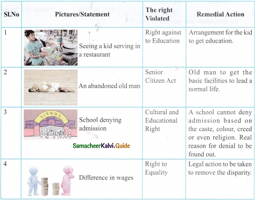
What are the Child Rights defined by the UNO?
Answer:
- Right to life
- Right to the family environment
- Right to Education
- Right to benefit from Social security
- Right against sexual exploitation
- Right against sale or trafficking
- Right against other forms of exploitation like Child labour.
Question 4.
Write a short note on the Right to Constitutional Remedies,
Answer:
- Fundamental Rights are guaranteed by the Constitution.
- By this right, a person can adopt Constitutional means and approach a court if he is denied the Fundamental Rights.
- The court then issues orders which are called ‘Writs’ to the government to restore the rights to the citizen.
- The Constitutional Remedies put to right anything which may be wrong in terms of the Constitution.
- This right, therefore, protects and safeguards all other rights.
Question 5.
Define: POCSO
Answer:
- The state should protect children from sexual exploitation and abuse when they are forced or persuaded to take part in sexual activities physically or mentally.
- The Protection of Children from Sexual Offences Act, 2012.
- Regards the best interest of the child as being of paramount importance at every stage.
![]()
Question 6.
Why do children need special attention?
Answer:
- Children are the future citizens of a nation.
- They should grow with warmth and interest.
- It helps the child feel secure and valued.
- From birth children need experiences and relationships that show them they are valued, capable human beings, who bring pleasure to others.
- Due special attention, the child’s image builds up overtime in a positive manner.
Question 7.
What are the contributions to labourers by B.R, Ambedkar?
Answer:
Dr. B.R. Ambedkar’s contribution to labourers.
- Reduction in Factory Working Hours (8 hours a day)
- Compulsory Recognition of Trade Unions
- Employment Exchange in India
- Employees State Insurance (ESI)
- Minimum Wages
- Coal and Mica Mines Provident Fund
Question 8.
‘All are equal before law’. But we have enacted a separate law for women – Justify
Answer:
- We have enacted a separate law for women to review the constitutional and legal safeguards for woman.
- It recommends remedial measures.
- Advises the government on all matters of policy affecting the welfare and development of women in the country.
- Women’s rights under the Constitution of India mainly include equality, dignity and freedom from discrimination.
![]()
Question 9.
Write about the Right against exploitation.
Answer:
It is against the law to employ children below 14 years of age in mines, factories, or other occupations. Neither contractor nor an employer can force a worker to do a job against their will.
Question 10.
Differentiate Fundamental Rights and Human Rights.
Answers:
Fundamental Rights:
- The elemental rights of the citizens of a country, which are listed in the constitution and enforceable under the law is known as fundamental rights.
- Fundamental rights include only those rights which are basic to a normal life.
- Fundamental rights are guaranteed under the constitution of the country.
Human Rights:
- The rights that a human being deserves to survive with respect and freedoms.
- Human rights include those rights which are basic to real life and are absolute, i.e. it cannot be taken away.
- Human rights are recognised at the international level.
V. Answer in detail
Question 1.
A paragraph about UDHR.
Answer:
- The Universal Declaration of Human Rights is a milestone document in the history of human rights.
- The Declaration was proclaimed by the United Nations General Assembly in Paris on 10th December 1948.
- The first time it sets out the fundamental human rights to be universally protected and the UDHR has been translated into many languages.
- There are 30 articles in the Universal Declaration of Human Rights and it guarantees freedom of expression as well as civil, political, social, economic and cultural rights. These rights apply to all people, irrespective of their race, gender and nationality, as all people are born free and equal.
![]()
Question 2.
What are the fundamental duties? How would you follow these in your school premises?
Answer:
The Fundamental Duties were incorporated in the Constitution by the 42nd Amendment Act in 1976. The Constitution states eleven Fundamental Duties. They are,
- Respect for the Constitution and its ideals and institutions, the National Flag and the National Anthem.
- To follow and cherish the noble ideals which inspired our National Struggle for freedom.
- To uphold and protect the sovereignty, unity and integrity of India.
- To defend the country and render national service when called upon to do so.
- To promote harmony and spirit of common brotherhood amongst all the people of India, transcending religious, linguistic, regional or sectional diversities, to renounce practices derogatory to the dignity of women.
- To value and preserve the rich heritage of our composite culture.
- To protect and improve the natural environment including forests, lakes, rivers and wildlife and have compassion on living creatures.
- To develop the scientific temper, humanism and the spirit of inquiry and reform.
- To safeguard public property and to abjure from violence.
- To strive towards excellence in all spheres of individual and collective activity, so that the nation constantly rises to higher levels of endeavour and achievements.
- To provide opportunities for education by the parent and guardian to their child or ward upto the age of 14 years.
- I would follow the relevant fundamental duties with determination and discipline.
Question 3.
How does the National Human Rights Commission protect our rights?
Answer:
- To inquire into the violation of human rights or negligence in the prevention of such violation by a public servant
- To intervene in court proceedings relating to human rights
- To undertake and promote research in the field of human rights
- To engage in human rights education among various sections of society
- To encourage the effects of NGOs and institutions working in the field of human rights.
![]()
Question 4.
What are the benefits for workers provided by labour law?
Answer:
(a) Due to Labour law, workers enjoy the following benefits,
- Reduction in Factory Working Hours (8 hours a day)
- Compulsory Recognition of Trade Unions
- Employment Exchange in India
- Employees State Insurance (ESI)
- Minimum Wages
- Coal and Mica Mines Provident Fund
(b) Women workers benefit the following,
- Mines Maternity Benefit Act
- Women Labour Welfare Fund
- Women and Child Labour Protection Act
- Maternity Benefit for Women Labour
- Restoration of Ban on Employment of Women on Underground Work in Coal Mines.
Question 5.
How do you enjoy the fundamental rights in your life?
Answer:
Right to Equality before the law and equal protection of the law. Prohibition of discrimination on the grounds of religion, caste, race, gender, or place of birth is offensive and one can seek justice from the court.
Right to Freedom: Six different types of freedom are mentioned in the Constitution. They are
- Freedom of speech and expression.
- Freedom to assemble peacefully without arms.
- Freedom to form associations and unions.
- Freedom to reside and settle in any part of India.
- Freedom to move freely throughout the territory of India.
- Freedom to practice any profession and carry on any occupation, trade, or business.
Right against Exploitation:
It is against the law to employ children below 14 years of age in mines, factories, or other occupations. Neither contractor nor an employer can force a worker to do a job against their will.
![]()
VI. Project and Activity
Question 1.
How do you protect yourself from child abuse / sexual exploitation and trafficking.
Answer:
Activity to be done by the students themselves
Question 2.
Write an article titled “My country, My Rights”.
Answer:
My Country, My Rights
Our country is a democratic country. We live independently with self-respect. We have lots of rights and responsibilities of our country. Rights and responsibilities are two sides of a coin and both go side by side. If we have rights we must have their corresponding responsibilities too. The rights and duties of each citizen are very valuable and inter-related.
Fundamental rights are given to each and every citizen for the basic and essential conditions of good life for the citizens’ welfare. Without such rights, no Indian citizen can develop his/her personality and confidence. These fundamental rights are preserved in the Indian Constitution.
There are six fundamental rights of the Indian citizens without which no one can live in the democratic manner. It means that democracy in the country can work only if its citizens have rights. Such rights prevent the government from being dictatorial and cruel. Fundamental rights help people in their moral, material and personality development. In case of rights violations of someone, courts can protect and safeguard the citizens.
Our country provides to all our citizens the necessary fundamental civil rights such as Right to Equality, Right to Freedom, Right against Exploitation, Right to Freedom of Conscience and Religion, Cultural and Educational Rights for minorities, Right to Constitutional Remedies. As being the citizen of the country, our responsibilities and duties are:
We must respect the National Flag and National Anthem.
We should respect and obey the laws of our country.
We should enjoy rights and freedom under the limit without interfering with freedom and rights of others.
We should be ready to protect our country whenever required.
We should respect and protect national property and public property (such as railways, post offices, bridges, roadways, schools, colleges, historical buildings, places, forests, etc).
We should pay our taxes with honesty in the stipulated time.
We should not waste electricity, water, natural resources, public property, etc.
So, we have to perform our duties sincerely to be a honest citizen, which is necessary for the development of our country.
Samacheer Kalvi 9th Social Science Human Rights Additional Important Questions and Answers
I. Choose the correct answer
Question 1.
UDHR played a crucial role in promoting ___________
(a) Individual Rights
(b) Fundamental Rights
(c) Human Rights
(d) None of the above
Answer:
(c) Human Rights
![]()
Question 2.
The life of people became meaningful through ___________
(a) Fundamental Rights
(b) Civics Rights
(c) Political Rights
(d) Cultural Rights
Answer:
(a) Fundamental Rights
Question 3.
Fundamental duties were incorporated in the Indian Constitution in the year ___________
(a) 1980
(b) 1975
(c) 1976
(d) 1950
Answer:
(c) 1976
Question 4.
Childline in India is ___________
(a) 100
(b) 108
(c) 1098
(d) 1028
Answer:
(c) 1098
Question 5.
NCW was constituted to safeguard ___________
(a) Children
(b) Labourers
(c) Students
(d) Women
Answer:
(d) Women
![]()
Question 6.
Which of the following statements are true?
(i) The general explanations of Human Rights by UDHR is not a legally binding document.
(ii) UDHR has political and moral importance.
(a) (i) is correct (ii) is wrong
(b) (i) is wrong (ii) is correct
(c) Both (i) and (ii) are wrong
(d) Both (i) and (ii) are correct
Answer:
(d) Both (i) and (ii) are correct
Question 7.
Consider the following statements-
Assertion (A): Child marriages should be avoided.
Reason (R) : When girls get married early, they lose many privileges thereby affecting the society as a whole.
(a) Both (A) and (R) are correct and (R) explains (A)
(b) Both (A) and (R) are correct but (R) does not explain (A)
(c) (A) is correct and (R) is false
(d) (A) is false and (R) is correct.
Answer:
(a) Both (A) and (R) are correct and (R) explains (A)
II. Fill in the blanks
- Gandhi was evicted from a first class compartment on the night of ___________
- UNO was established in the year ___________
- UNO was formed after ___________
- In 1994 ___________ became the President of South Africa.
- The milestone document in the history of human rights is ___________
- Political rights are given to the citizens by ___________
- The written order from the court or other legal authority is called a ___________
- Protection and promotion of human rights is India in the responsibility of ___________
- Malala shared the Nobel Peace prize with ___________
- One of the RTI activists is ___________
Answer:
- 7th June 1893
- 1945
- Second world war
- Nelson Mandela
- the Universal Declaration of Human rights
- Law
- Writ
- NHRC
- Kailash Satyatarathi
- Aruna Roy / Nikil Dey
III. Match the following
Question 1.
- F. W. de Klerk – (i) Fundamental duty
- To defend the country – (ii) Fundamental Right
- Freedom of Speech – (iii) SHRC
- Recommend compensation to victims – (iv) Child Right
- Family Environment – (v) President
Answer:
- – (v)
- – (i)
- – (ii)
- – (iii)
- – (iv)
IV. Give short answers
Question 1.
What are Extended rights?
Answer:
The Child rights, SC and ST rights, Women rights, Right to Information Act (RTI) and Labour laws come under Extended rights.
![]()
Question 2.
What is Apartheid?
Answer:
Apartheid means social discrimination. Apartheid was the highest form of discrimination that existed in South Africa. Places of residences were determined by racial classification. It was the governing policy in the country by the minority whites over the majority non-whites. The people of South Africa protested against racial discrimination.
Question 3.
What is Apartheid?
Answer:
- Apartheid means social discrimination.
- Apartheid was the highest form of discrimination that existed in South Africa.
- Places of residences were determined by racial classification.
- It was the governing policy in the country by the minority whites over the majority non-whites.
- The people of South Africa .protested against racial discrimination.
![]()
Question 4.
Write a note on Nelson Mandela.
Answer:
- Nelson Mandela raised his voice against Apartheid.
- When he organised defiant campaigns against the government, he was imprisoned.
- He was released in 1990 by President F.W. de Klerk.
- The efforts taken by Mandela and de Klerk put an end to apartheid.
- In 1994, a general election was held and Nelson Mandela, the leader of the African National Congress, became President.
Question 5.
What do the 30 articles of UDHR guarantee?
Answer:
- There are 30 articles in the Universal Declaration of Human Rights.
- It guarantees freedom of expression as well as Civil, Political, Social, Economic and Cultural Rights.
- These rights apply to all people, irrespective of their race, gender and nationality, as all people are bom free and equal.
Question 6.
What are the social and economic rights assured by UDHR?
Answer:
- Social rights are necessary for full participation in society.
- Economic rights guarantee every person to have conditions under which they are able to meet their needs.
- They are a part of a range of legal principles through which economic equality and freedom are preserved in a State.
Question 7.
What are the cultural rights assured by UDHR?
Answer:
Cultural rights are human rights that aim at assuring the enjoyment of culture and its components in conditions of equality, human dignity and non-discrimination.
![]()
Question 8.
What does the term Civil rights refer to?
Answer:
- The term ‘Civil rights’ refers to the basic rights afforded by laws of the government.
- It is guaranteed to every person regardless of race, nationality, colour, gender, age, religion etc.
Question 9.
What Is meant by political rights?
Answer:
- Political rights exercised in the formation and administration of a government.
- They are given to the citizens by law.
- These rights give power to the citizens to participate either directly or indirectly in the administration.
Question 10.
Write a note on the Right to Equality.
Answer:
- Right to Equality refers to equality before the law and equal protection of the law.
- Prohibition or discrimination on the grounds of religion, caste, races, gender or place of birth is offensive.
- One can seek justice from the court if such a situation does arise.
Question 11.
Explain the Right against exploitation.
Answer:
- It is against the law to employ children below 14 years of age in mines, factories, or other occupations.
- Neither contractor nor an employer can force a worker to do a job against their will.
Question 12.
How are people assure of freedom of religion?
Answer:
- The right to freedom of conscience and religion gives the citizens freedom to follow and practice a religion of their choice.
- All citizens have the freedom of conscience or ideas.
- The citizens also have the freedom to follow their own ways of practicing any religion.
![]()
Question 13.
What is a Writ?
Answer:
Writ is a written order from the court or other legal authority ordering to do an act or not to do it.
Question 14.
How are senior citizens legally protected?
Answer:
- Senior citizens Act was passed in 2007 by the Government of India to maintain the welfare of parents.
- This Act is a legal obligation for children and heirs to provide maintenance to senior citizens and parents.
Question 15.
What is NHRC?
Answer:
- The National Human Rights Commission (NHRC) is an autonomous body constituted on 12th October 1993 under the protection of the Human Rights Act, 1993.
- It consists of a chairman and a few other members.
- NHRC is responsible for the protection and promotion of human rights in India.
- The Act defines the right relating to life, liberty, equality, and dignity of the individual guaranteed by the Constitution or embodied in the international covenants.
Question 16.
What is SHRC?
Answer:
- SHRC refers to State Human Rights Commission.
- Every state in India has a State Human Rights Commission established in accordance with the power conferred on the state under section 21 of the Protection of Human Rights Act, 1993.
- The protection and promotion of human rights constitute the principal concern of the Commission.
Question 17.
When were the Rights of the child accepted by the UNO?
Answer:
- A child is a person who has not completed the age of 18 years i.e. a minor as per UNO.
- This principle is exhibited in Articles 25 of the Universal Declaration of Human Rights.
- Based on these principles, the declaration of the Rights of the child was accepted and adopted in the UN General Assembly on 20th November, 1989.
Question 18.
What is Childline?
Answer:
- Child line (1098) is India’s first 24 hours free emergency phone service for. children in need of assistance.
- Special care is given for vulnerable children like those affected by child labour, child marriage and children affected by any abuse.
![]()
Question 19.
Where do we find Child Rights in the Indian constitution?
Answer:
- Article 24 – No child below the age of 14 must be employed in hazardous employment.
- Article 45- Free and compulsory education for all children until they attain the age of 14 years.
Question 20.
Children are the foundation of any nation.
Answer:
- Children are the foundation of any nation
- When girls get married early, they lose many privileges like childhood happiness, availing education and a healthy life.
- The society in turn gets affected by child marriage.
- Thus child marriage should be avoided at any cost.
Question 21.
Why is the National Commission for Women a council?
Answer:
- The National Commission for Women (NCW) is constituted in India to review the Constitutional and legal safeguards for women.
- It recommends remedial measures and advises the government on all matters of policy affecting the welfare and development of women in the country.
Question 22.
What are Women’s Rights?
Answer:
- Women’s Rights are under the Indian Constitution mainly includes equality, dignity and freedom from discrimination.
- Additionally, India has various statutes governing the right of women.
![]()
Question 23.
Mention about Women Labourers’ Welfare and Dr. B.R.Ambedkar.
Answer:
- Dr. B.R. Ambedkar framed many laws for women workers in India.
- They are
- ‘Mines Maternity Benefit Act’,
- ‘Women Labour Welfare Fund’,
- ‘Women and Child Labour Protection Act’,
- ‘Maternity Benefit for Women Labour’,
- ‘Restoration of Ban on Employment of Women on Underground Work in Coal Mines’.
Question 24.
What are SC and ST Rights?
Answer:
- In order to ensure the dignity and security of Adi Dravidars (mostly referred as Scheduled Castes in other States) their rights are ensured.
- They remove all forms of exclusion, marginalization, untouchability and discrimination
- The Government formulate policies, plans, budgets, schemes and programmes.
- This is done to ensure their right to social equity, access to entitlements and right to dignity.
- These rights facilitate the betterment of their socio-economic conditions as well as conferring democratic and political rights.
Question 25.
What is RTI?
Answer:
- RTI refers to the Right to Information Act.
- It is a revolutionary act that aims to promote transparency in the government institutions in India.
- This act was enacted in October 2005.
- A common man can demand any government organization to provide information.
- The information must be provided within thirty days.
- If not, a fee will be collected as a penalty from the concerned official.
Question 26.
What are Labour Rights?
Answer:
- The Constitution ensures right to equality, equality of opportunity in public employment, right to form associations and unions, right to livelihood.
- It prohibits trafficking, forced labour and child labour.
- Article 39(d) ensures equal wages to male and female workers for equal work.
V. Answer in detail
Question 1.
What are the functions of SHRC?
Answer:
The functions of SHRC are
- The SHRC shall enquire into violation of human rights in respect of matters specified in the state and concurrent lists.
- Its objectives and duties are the same as NHRC, but confined only to the state. It has a chairman and two members.
- It has the power of a civil court and can take cognizance of cases if received.
- It can also recommend compensation to victims.
![]()
Question 2.
Democracy, Development and Fundamental Rights can you establish a positive link among these three factors.
Answer:
- Democracy has an important role to play in promoting sustainable development.
- Free and fair elections, independent media, accountable government as well as other basic democratic principles are all critical components of an environment and conducive to growth.
- In a direct democracy, the people decide on the policy initiatives directly.
- Democracy is very much responsible and important for the development of a nation.
- In a democratic country the citizens are force to express their views and opinions on decisions taken by government.
- This makes the government take more responsible decisions and they go with majority people.
- All these actions can be carried on with the help of the fundamental rights generated by the constitution of India with legal background.
Question 3.
Explain Child Rights.
Child Rights are,
(a) Right to life:
- A child has the right to survive even before its birth.
- The right to survival also includes the right to be bom, the right to basic needs of food, shelter and clothing and a dignified living.
(b) Right to the Family environment:
- A child has the right to live a normal childhood in a family environment.
- Children who have been left destitute, abandoned or orphaned also have the right to live.
- These children can be given for adoption to caring families.
(c) Right to benefit from Social security:
- Children should get financial support from the country when their parents or guardians are unable to provide them with a good standard of living by themselves, due to any illness, disability or old age.
(d) Right to Education:
- Right to Education Act is an Act of the Parliament of India enacted in 2009 for free and compulsory education for children from 6 to 14 years of age as under Article 21A of the Constitution.
(e) Right against sale or trafficking:
- Children should be treated as individuals with fundamental human rights.
- They are subj ected to sale or trafficking for various reasons like economic exploitation, sexual exploitation, sexual abuse, drug trafficking and child labour.
![]()
(f) Right against sexual exploitation:
- The state should protect children from sexual exploitation and abuse.
- This is done through POCSO Act – Protection of Children from Sexual Offences Act in 2012.
(g) Right against other forms of exploitation like Child labour:
- Children are often employed in several industries.
- These children are deprived of their childhood, health, and education.
Question 4.
Explain the Right to Information Act (RTI).
Answer:
- The Right to Information Act is a revolutionary act that aims to promote transparency in the government institutions in India.
- This act was enacted in October 2005.
- A common man can demand any government organization to provide information.
- The information must be provided within thirty days.
- If not, a fee will be collected as penality from the concerned official
It is one of the most powerful laws of the country. - This act is people-friendly; even an illiterate person can ask any Public Information Officer to write it down for him.
- All government agencies like Municipal Corporations, Government departments, Government Schools, Road Authorities, etc., come under this Act.
Life Skills