Students can download 6th Social Science Term 3 Geography Chapter 2 Globe Questions and Answers, Notes, Samacheer Kalvi 6th Social Science Guide Pdf helps you to revise the complete Tamilnadu State Board New Syllabus, helps students complete homework assignments and to score high marks in board exams.
Tamilnadu Samacheer Kalvi 6th Social Science Geography Solutions Term 3 Chapter 2 Globe
Samacheer Kalvi 6th Social Science Globe Text Book Back Questions and Answers
I. Fill in the blanks
- The line of latitude which is known as the Great Circle is ……………..
- The imaginary lines drawn horizontally on Earth from the West to East are called ……………..
- The 90° lines of latitude on the Earth are called ……………..
- The Prime Meridian is also called ……………..
- The world is divided into …………….. time zones.
Answer:
- Equator
- lines or parallels of latitude
- Poles
- Greenwich meridian
- 24
II. Choose the best answer
Question 1.
The shape of the Earth is ……………..
(a) Square
(b) Rectangle
(c) Geoid
(d) Circle
Answer:
(c) Geoid
Question 2.
The North Pole is _______.
(a) 90° N Latitude
(b) 90° S latitude
(c) 90° W Longitude
(d) 90° E longitude
Answer:
(a) 90° N Latitude
Question 3.
The area found between 0° and 180° E lines of longitude is called ……………..
(a) Southern Hemisphere
(b) Western Hemisphere
(c) Northern Hemisphere
(d) Eastern Hemisphere
Answer:
(d) Eastern Hemisphere
Question 4.
The 23 ° N line of latitude is called _______.
(a) Tropic of Capricorn
(b) Tropic of Cancer
(c) Arctic Circle
(d) Antarctic Circle
Answer:
(b) Tropic of Cancer
![]()
Question 5.
180° line of longitude is ……………..
(a) Equator
(b) International Date Line
(c) Prime Meridian
(d) North Pole
Answer:
(b) International Date Line
Question 6.
The Sun is found overhead the Greenwich Meridian at ________
(a) 12 midnight
(b) 12 noon
(c) 1 p.m.
(d) 11 a.m.
Answer:
(b) 12 noon
Question 7.
A day has ……………
(a) 1240 minutes
(b) 1340 minutes
(c) 1440 minutes
(d) 1140 minutes
Answer:
(c) 1440 minutes
Question 8.
Which of the following lines of longitude is considered for the Indian Standard Time?
(a) 82 1/2° E
(b) 82 1/2° W
(c) 811/2° E
(d) 81 1/2° W
Answer:
(a) 82 1/2° E
Question 9.
The total number of lines of latitude are ……………
(a) 171
(b) 161
(c) 181
(d) 191
Answer:
(c) 181
![]()
Question 10.
The total number of lines of longitude are ________
(a) 370
(b) 380
(c) 360
(d) 390
Answer:
(c) 360
III. pic the odd one Answer
Question 1.
North Pole, South Pole, Equator, International Date Line.
Answer:
International Dateline
Question 2.
Tropic of Capricorn, Tropic of Cancer, Equator, Prime Meridian.
Answer:
Prime Meridian
Question 3.
Torrid Zone, Time Zone, Temperate Zone, Frigid Zone
Answer:
Time Zone
![]()
Question 4.
Royal Astronomical Observatory, Prime Meridian, Royal Astronomical Greenwich Meridian, International Date Line.
Answer:
Royal Astronomical observatory
Question 5.
10° North, 20° South, 30°, North, 40° West
Answer:
40° west.
IV. Match the following
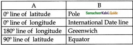
Answer:
1. – d
2. – c
3. – b
4. – a
V. Examine the following statements
1. The Earth is spherical in shape.
2. The shape of the Earth is called a geoid.
3. The Earth is flat.
Look at the options given below and choose the correct answer
(a) 1 and 3 are correct
(b) 2 and 3 are correct
(c) 1 and 2 are correct
(d) 1, 2, and 3 are correct
Answer:
(c) 1 and 2 are correct
VI. Examine the following statements
Question 1.
Statement I: The lines of latitude on Earth are used to find the location of a place and define the heat zones on Earth.
Statement II: The lines of longitudes on Earth are used to find the location of a place and to calculate time.
Choose the correct option:
(a) Statement I is correct; II is wrong
(b) Statement I is wrong; II correct
(c) Both the statements are correct
(d) Both the statements are wrong
Answer:
(a) Statement I is correct; II is wrong
VII. Name the following
Question 1.
The imaginary lines are drawn horizontally on Earth
Answer:
Lines of latitude/parallels
Question 2.
The imaginary lines are drawn vertically on Earth.
Answer:
Lines of longitude /Meridians
![]()
Question 3.
The three dimensional model of the Earth.
Answer:
Globe
Question 4.
India is located in this hemisphere based on lines of longitude.
Answer:
Southern Hemisphere
Question 5.
The network of lines of latitude and longitude.
Answer:
Earth grid / Geographic grid
VIII. Answer briefly
Question 1.
What is a geoid?
Answer:
- The Earth cannot be compared with any other geometrical shape as it has a very unique shape.
- Hence, its shape is called a geoid (earth shaped).
Question 2.
What is the local time?
Answer:
- When the sun is overhead on a particular line of longitude, it is 12 moon at all the places located on that line of longitude.
- This is called local time.
Question 3.
How many times would the sun pass overhead a line of longitude?
Answer:
The sun is overhead on a line of longitude only once a day.
![]()
Question 4.
What are lines of latitude and longitude?
Answer:
- There are imaginary lines which are drawn on the globe horizontally and vertically to find a location and calculate distance and time.
- These imaginary lines are called lines of latitudes and longitudes.
Question 5.
Name the four hemispheres of the Earth.
Answer:
- Northern Hemisphere,
- Southern Hemisphere,
- Eastern Hemisphere and
- Western Hemisphere.
IX. Give reason
Question 1.
The 0° line or longitude is called the Greenwich Meridian.
Answer:
The 0° line of longitude is called the Greenwich Meridian because it passes through Greenwich.
Question 2.
The regions on Earth between North & South lines of latitude (66 Vi°) and poles (90°) is called Frigid Zone.
Answer:
- From the Arctic circle (66 ‘A° N) to the North Pole (90° N) and from the Antarctic circle (66 Vi0 S) to the South Pole (90° S) the sun’s rays full further inclined, through out the year.
- The temperature is very low.
- Hence this region is known as Frigid Zone.
![]()
Question 3.
The International Date Line runs zigzag.
Answer:
If the International Date line is drawn straight, two places in the same country would have different dates. So the International date line is found Zig Zag to avoid confusion.
X. Answer in detail
Question 1.
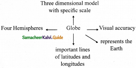
What are the uses of globe?
Answer:
- Since the Earth is huge and we live on a very area, we are not able to see the Earth as a whole.
- But when we travel to space, we can see the Earth as a whole.
- So, in order to see the shape of the Earth as a whole and to know its unique features, a three-dimensional model of the Earth was created with a specific scale in the name of the globe.
Question 2.
How are the hemispheres divided on the basis of lines of latitude and longitude? Explain with diagrams.
Answer:
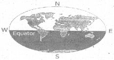
Northern Hemisphere:
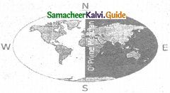
Northern Hemisphere. The area of the Earth found between the Equator (Oo) and the North pole (90oN) is called the Northern Hemisphere.
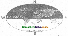
Southern Hemisphere:
Southern Hemisphere. The area of the Earth from the Equator (0°) and the South pole (90°S) is called the Southern Hemisphere.
Eastern Hemisphere:
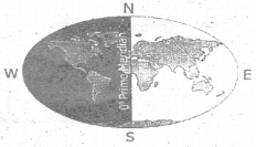
Eastern Hemisphere. The part of the Earth between the 0° line of longitude and 180° East line of longitude is known as the Eastern Hemisphere.
Western Hemisphere
Western Hemisphere. The part of the Earth from Oo line of longitude and 180° West line of longitude is called as Western Hemisphere.
Question 3.
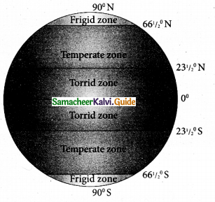
What are the significant lines of latitude? Explain the zones found between them.
Answer:
- The significant lines of latitude are
- Equator 0°
- Tropic of cancer 23 1/2° N
- Tropic of Capricorn 23 1/2° S
- Arctic Circle 66 1/22°N
- Antarctic Circle 66 1/2° S
- North Pole 90° N
- South Pole 90° S
- Based on the amount of heat received from the sun, our world is broadly divided into three heat zones.
1. The Torrid Zone : On both sides of the equator, the region lying between the Tropic of cancer and Tropic of Capricorn is called the Torrid zone. This zone gets the direct rays of the sun all the year round. Hence the climate is hot and humid.
2. The Temperature Zone : This zone is neither hot nor very cold. It lies between the Torrid zone and Frigid zone in both the hemispheres.
3. The Frigid Zone : The region lying between the Arctic circle and North pole and between Antarctic circle and south pole is called the frigid zone. It receives very slanting rays of the sun and is therefore very cold.
Question 4.
Explain : Indian Stanard Time.
Answer:
- The longitudinal extent of India is from 68° 7’E to 97° 25’E
- Twenty nine lines of longitude pass through India.
- Having 29 standard time is not logical
- Hence 821/2° E line of longitude is observed as the prime meridian to calculate the Indian standard Time (IST)
XI. Activity
There are five Posistion marked on the grid given below. Look at them carefully and fill the blanks with reference to the lines of latitude and longitude. The first one is done for you.
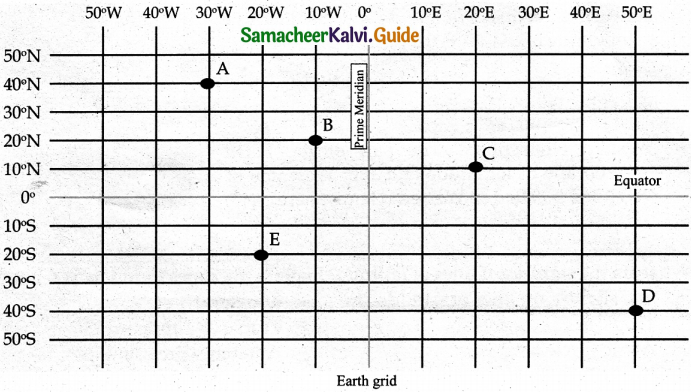
- The latitudinal and longitudinal reference of point A 40° N 30°W
- The latitudinal and longitudinal reference of point B 20° N 10°W
- The latitudinal and longitudinal reference of point C 10° N 20°W
- The latitudinal and longitudinal reference of point D 40° N 50°W
- The latitudinal and longitudinal reference of point E 20° N 20°W
Samacheer Kalvi 6th Social Science Globe Additional Important Questions and Answers
I. Fill in the blanks Answer
- The surface area of the Earth is ………….. million square kilometres.
- ………….. was the first person to draw the lines of latitude and longitude on a map
- The Royal Astronomical observatory is located at …………..
- The directions on the ground are always shown with respect to the …………..
- There are four ………….. directions.
Answer:
- 510.1
- Ptolemy
- Greenwich
- North
- Cardinal
II. Answer the following questions
Question 1.
Who said this? The stars in the sky seem to move towards the west because of the Earth’s rotation on its axis
Answer:
Aryabhata – The Indian astronomer
Question 2.
Who wrote the book ‘Geographia’?
Answer:
Ptolemy, (a Greco – Roman mathematician (astronomer and geographer)
![]()
Question 3.
Name the country that has 7 time zones.
Answer:
Russia
III. Answer in briefly
Question 1.
Define Meridian
Answer:
The word meridian is derived from the latin word ‘Meridianus’. It means mid day. So, meridian means the postion of the sun overhead at the place at noon.
Question 2.
What is an axis?
Answer:
- An imaginary line around which a large round object such as the Earth turns.
- The Earth rotates on its axis between the north and South Poles.
Question 3.
What is hemisphere?
Answer:
A half of the earth usually as divided into Northern and Southern halves by the equator or into Western and Eastern halves by an imaginary line passing through the poles.
IV. Choose the correct answer
Question 1.
23 1/220° N and S 66 1/220° N and S lines of latitudes are called ……………..
(a) Low latitudes
(b) Middle latitudes
(c) High latitudes
Answer:
(b) Middle latitudes
Question 2.
The Sun’s rays fall vertically in this region.
(a) Frigid Zone
(b) Temperate Zone
(c) Torrid Zone
Answer:
(c) Torrid Zone
![]()
Question 3.
High latitudes are there between
(a) 66 1/2°N and S – 90°N and S
(b) 231/2°N and S and 66f°N and S
(c) 0° – 23 1/2°N and S
(d) North poles
Answer:
(a) 66 1/2° N and S – 90°N and S
Question 4.
Latitudes are also known as ……………..
(a) Nilavangu
(b) Ahalangu
(c) Nettangu
Answer:
(b) Ahalangu
Question 5.
Lines of latitudes merge
(a) at poles
(b) at the equator
(c) at International Date line
(d) do not merge
Answer:
(d) do not merge
V. Match the following
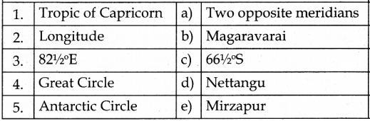
Answer:
1. – b
2. – d
3. – e
4. – a
5. – c
VI. Answer in detail
Question 1.
Draw the Heat Zones of the Earth
Answer:
VII. Mind map