Tamilnadu State Board New Syllabus Samacheer Kalvi 8th Social Science Guide Pdf History Chapter 3 Rural Life and Society Text Book Back Questions and Answers, Important Questions, Notes.
Tamilnadu Samacheer Kalvi 8th Social Science Solutions History Chapter 3 Rural Life and Society
Samacheer Kalvi 8th Social Science Rural Life and Society Text Book Back Questions and Answers
I. Choose the correct answer.
1. Which system was called by different names like Jagirdari, Malguzari and Biswedari etc.?
a) Mahalwari
b) Ryotwari
c) Zamindari
d) None of these
Answer:
c) Zamindari
2. Under which Governor General did the permanent settlement implemented in Bengal,
a) Lord Hastings
b) Lord Cornwallis
c) Lord Wellesley
d) Lord Minto
Answer:
b) Lord Cornwallis
3. What was the Mahal in the Mahalwari system?
a) House
b) Land
c) Village
d) Palace
Answer:
c) Village
4. In which region was the Mahalwari system imposed?
a) Maharashtra
b) Madras
c) Bengal
d) Punjab
Answer:
d) Punjab
5. Who among the following Governors introduced Mahalwari system?
a) Lord Hastings
b) Lord Cornwallis
c) Lord Wellesley
d) Lord William Bentinck
Answer:
d) Lord William Bentinck
6. In which region was the Ryotwari system not introduce by the British?
a) Bombay
b) Madras
c) Bengal
d) None of these
Answer:
c) Bengal
7. The Indigo revolt was led by whom?
a) Mahatma Gandhi
b) Keshab Chandra Roy
c) DigambarBiswas and BishnuBiswas
d) Sardar Vallabhai Patel
Answer:
c) Digambar Biswas and Bishnu Biswas
8. The Bardoli Satyagraha was led by whom?
a) Sardar Vallabhbhai Patel
b) Mahatma Gandhi
c) DigambarBiswas
d) Keshab Chandra Roy
Answer:
a) Sardar Vallabhbhai Patel
II. Fill in the Blanks:
1. ……………. is the modified version of the Zamindari system.
Answer:
Mahalwari Settlement
2. The Mahalwari system was a Brain child of ……………. .
Answer:
Holt Mackenzie
3. Indigo Revolt took place in ……………. .
Answer:
Bengal
4. Maplah Rebellion was held in ……………. .
Answer:
Malabar
5. The Champaran Agrarian Act was passed in ……………. .
Answer:
May 1918
III. Match the following.
| 1. Permanent Settlement | a) Madras |
| 2. Mahalwari Settlement | b) Misery of the Indigo cultivators |
| 3. Ryotwari System | c) North west province |
| 4. Nil Darban | d) Bengal |
| 5. Santhal Rebellion | e) First Peasant revolt |
Answer:
| 1. Permanent Settlement | d) Bengal |
| 2. Mahalwari Settlement | c) North west province |
| 3. Ryotwari System | a) Madras |
| 4. Nil Darban | b) Misery of the Indigo cultivators |
| 5. Santhal Rebellion | e) First Peasant revolt |
IV. State true or false.
1. Warren Hastings introduced quinquennial land settlement.
Answer:
True
2. Ryotwari system was introduced by Thomas Munro.
Answer:
True
3. Pabna revolt originated in the Yusufshahi pargana in Gujarat.
Answer:
False
4. The Punjab land alienation Act was passed in 1918.
Answer:
False
V. Consider the follbwing statement and tick appropriate answer.
1. Which of the following statement is not true about Zamindari system?
a) This settlement was introduced in 1793.
b) The Zamindars became the owner of the land.
c) This system secured a fixed stable income for the cultivators.
d) This practice was applicable to the area of 19% of India.
Answer:
c) This system secured a fixed stable income for the cultivators.
2. Which of the following statement is correct about Peasants revolt in India?
a) The Santhal rebellion was held in Bengal.
b) Dinabandhu Mitra wrote a drama called Nil Darban.
c) The Deccan riots started from a village at Pune in 1873.
d) The Moplah peasants rebellion was held in Tamil Nadu.
Answer:
b) Dinabandhu Mitra wrote a drama called Nil Darban.
VI. Answer the following in one or two sentences.
1. List out any two salient features of the Permanent Settlement?
Answer:
Salient features of the Permanent settlement:
- The Zamindars were recognized as the owners of the land as long as they paid the revenue to the East India Company regularly.
- The Zamindars acted as the agent of the Government for the collection of revenue from the cultivators.
2. What were the salient features of the Ryotwari system?
Answer:
- Revenue settlement was done directly with the ryots.
- Measurement of field and an estimate of the product was calculated.
- The government fixed the demand at 45% to 55% of the produce.
3. Bring out the effects of the Mahalwari settlement.
Answer:
Effects of the Mahalwari settlement:
- The Lambardar enjoyed privileges which were misused for their self – interest.
- This system brought no benefit to the cultivators.
- It was a modified version of the Zamindari system and benefited the upper class in villages.
4. What was the cause of the Indigo Revolt in 1859 – 60?
Answer:
- The European indigo planters compelled the tenant farmers to grow indigo at terms highly disadvantageous to the farmers.
- The tenant farmer was forced to sell it cheap to the planter and accepted advances from the planter that benefitted the latter.
- There were also cases of kidnapping, looting, flogging, and burning.
- Led by Digambar Biswas and Bishnu Charan Biswas, the ryots of the Nadia district gave up indigo cultivation in September 1859.
- Factories were burnt down and the revolt spread.
5. What was the contribution of Mahatma Gandhi on Champaran Satyagraha.
Answer:
- The European planters of Champaran in Bihar resorted to illegal and inhuman methods of indigo cultivation at a cost which was wholly unjust.
- The peasants were liable to unlawful extortion and oppression by the planters.
- Mahatma Gandhi took up their cause. The Government appointed an enquiry commission of which Mahatma Gandhi was a member.
- The grievances of the peasants were enquired and ultimately the Champaran Agrarian Act was passed in May 1918.
6. Mention the role of Vallabhai Patel in Bardoli Satyagraha.
Answer:
- By the leadership of Sardar Vallabhbhai Patel, in protest against the government’s proposal to increase land revenue by 30%.
- Women have participated in the campaign.
- All the land return to farmers by Congress in 1937.
VII. Answer the following in detail.
1. Discuss the merits and demerits of the Permanent Settlement.
Answer:
Merits:
- Under this system, many of the wastelands and forests became cultivable lands.
- The Zamindars became the owner of the land.
- The Zamindars were made free from the responsibility of providing justice.
- The Zamindars remained faithful to the British Government.
- This system secured a fixed and stable income for the British Government.
Demerits:
- The British Government had no direct contact with the cultivators.
- The rights of the cultivators were ignored and they were left at the mercy of the Zamindars.
- The peasants were almost treated as serfs.
- This system was made the Zamindars lethargic and luxurious.
- Many conflicts between the zamindars and the peasants arose in rural Bengal.
2. What were the impacts of the British Land Revenue system on the cultivators?
Answer:
Impact of the British land revenue system on the cultivators:
- A common feature of all the settlements was the assessment and the maximize income from land. It resulted in increasing land sales and dispossession.
- The peasants were overburdened with taxation and the peasants to seek moneylenders who became rich and acquired lands from the peasants.
- The money lenders, the Zamindars, and lawyers exploited the poor peasants.
- The stability and continuity of the Indian villages were shaken.
- Cottage industries disappeared.
- The British policy proved advantageous only to the government of a privileged section of the society at the cost of cultivators who were the rightful owners of their lands and claimants of the larger share of the produce.
3. Write a paragraph about the Moplah Rebellion?
Answer:
Moplah Rebellion (1921):
1. The Muslim Moplah (or Moplah) peasants of Malabar (Kerala) were suppressed and exploited by the Hindu zamindars (Jenis) and the British government.
2. This was the main cause of this revolt.
3. The Moplah peasants got momentum from the Malabar District Conference, held in April 1920.
4. This conference supported the tenant’s cause and demanded legislation for regulating landlord-tenant relations.
5. In August 1921, the Moplah tenants rebelled against the oppressive zamindars. In the initial phase of the rebellion, the Moplah peasants attacked the police stations, public offices, communications and houses of oppressive landlords and moneylenders.
6. By December 1921, the government ruthlessly suppressed the Moplah rebellion.
7. According to an official estimate, as a result of government intervention, 2337 Moplah rebels were killed, 1650 wounded and more than 45,000 captured as prisoners.
VIII. HOTS:
1. Apart from the exploiting through taxes, how did the British further exploit the land?
Answer:
Apart from the taxes, the British followed the policy of commercialization of Agriculture which was a major setback for Indian farmers. They were forced to grow the soil fertility deteriorating cash crops such as opium. Jute, Indigo, etc., Agricultural prices shot up by 31%. They were threatened if they failed to grow these crops.
Samacheer Kalvi 8th Social Science Rural Life and Society Additional Important Questions and Answers
I. Choose the Correct answer.
1. Permanent settlement introduced in the year ………………
a) 1739
b) 1756
c) 1730
d) 1793
Answer:
d) 1793
2. Ryotwari system was introduced by Thomas Munro and Captain …………….. .
a) Captain Read
b) Captain Hawkins
c) Captain Feral
d) Captain William
Answer:
a) Captain Read
3. Poor peasants exploited by ………………
a) Govt officials
b) Money – Lenders
c) Police
d) Judges
Answer:
b) Money – Lenders
4. Lord Cornwallis Settlement was introduced for how many years?
a) 10
b) 12
c) 15
d) 20
Answer:
a) 10
5. Mahalwari system introduced by Lord ………………
a) Sir – Thomas Munro
b) William Bentinck
c) Wellesley
d) Dalhousie
Answer:
b) William Bentinck
6. The Ryotwari system introduced in the year ………………
a) 1800
b) 1810
c) 1815
d) 1820
Answer:
d) 1820
7. Indigo commission formed in the year ………………
a) I860
b) 1855
c) 1865
d) 1862
Answer:
a) 1860
8. The first revolt which can be regarded as peasants revolt was the ………………
a) Indigo Revolt
b) Santhal Rebellion
c) Pabna Revolt
d) Deccan Riots
Answer:
b) Santhal Rebellion
9. Deccan Riots held in …………….. districts.
a) Punjab
b) Bihar
c) Poona
d) Thanjavur
Answer:
c) Poona
10. No tax movement started in the year ………………
a) 1920
b) 1923
c) 1925
d) 1918
Answer:
d) 1918
II. Fill in the Blanks.
1. Indian economy was predominantly an …………….. economy.
Answer:
Agrarian
2. Robert clive obtained the Diwani of Bengal in the year ………………
Answer:
1765
3. Permanent system introduced by ………………
Answer:
Lord Cornwallis
4. Ryotwari system introduced by …………….. and ………………
Answer:
Thomas Munro and Captain Read
5. Permanent settlement system also known as …………….., …………….., …………….., and ………………
Answer:
Zamindari, Jagirdari, Malguzari and Biswedari
6. In Mahalwari settlement, the tax was collected through ………………
Answer:
Lambardar
7. Dina bandu mitra wrote a drama, ……………..
Answer:
Nil – Darpan
8. …………….. Bengali drama to draw the misery of the indigo – cultivators.
Answer:
Siddhu and Kanhu
9. Pabna Revolt led by ………………
Answer:
Keshab Chandra Roy
10. The Punjab land Alienation act was passed in
Ans: 1900
11. …………….. accepted the leadership of Kheda satyagraha.
Answer:
Gandhi
12. The Moplahs are ………………
Answer:
Muslim Peasants
13. Nil – Darpan drama wrote in …………….. Language
Answer:
Bengali
14. The Government set up an Indico commission in ____________
Answer:
1860
15. In the permanent settlement system, the zamindars would grant to the ryots.
Answer:
Patta
III. Match the following.
| 1. Bihar | a) Kheda |
| 2. Bengal | b) Pabna |
| 3. Deccan | c) Malabar |
| 4. Gujarat | d) Santhal |
| 5. Kerala | e) Poona |
Answer:
| 1. Bihar | d) Santhal |
| 2. Bengal | b) Pabna |
| 3. Deccan | e) Poona |
| 4. Gujarat | a) Kheda |
| 5. Kerala | c) Malabar |
IV. State True or False.
1. The Muslim peasants were called Moplah.
Answer:
True
2. Mahalwari settlement system brought benefit to the cultivators
Answer:
False
3. Champaran has situated in the state of Bihar.
Answer:
True
4. The first revolt which can be regarded as a peasants revolt was the Santhal Rebellion in 1855 – 1656.
Answer:
True
5. In 1876, the peasants revolted in the district of Poona in the Deccan Riots.
Answer:
False
V. Consider the following statement and tick the appropriate answer.
a) Ryotwari Revenue settlement was done indirectly with the ryots.
b) Measurement of field and an estimate of produce was not calculated.
c) Government fixed the demand at 45% to 55 % of the produce.
d) In most areas the land revenue fixed was less.
Answer:
c) Government fixed the demand at 45% to 55 % of the produce.
VI. Answer the following in one or two sentences.
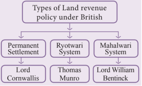
1. What are the three major land revenue systems introduced by the British in India? Who made that system.
Answer:
2. What are the salient features of the Mahalwari settlement?
Answer:
- The Lambardar acted as intermediaries between the Government and the villagers.
- It was a village-wise assessment. One person could hold a number of villages.
- The village community was the owner of the village common land.
- The village land belonged to the village community.
VII. Answer the following in detail.
1. Explain the Permanent Land Revenue settlement.
Answer:
- When Robert Clive obtained the Diwani of Bengal, Bihar, and Orissa in 1765, there used to be an annual settlement (of land revenue).
- Warren Hastings changed it from annual to quinquennial (five-yearly) and back to annual again.
- During the time of Cornwallis, a ten years’ (decennial) settlement was introduced in 1793 and it was known as Permanent Settlement.
- The permanent settlement was made in Bengal, Bihar, Orissa, Varanasi division of U.P., and Northern Karnataka, which roughly covered 19 percent of the total area of British India.
- It was known by different names like Zamindari, Jagirdari, Malguzari, and Biswedari.
2. Give an account of the Santhal Rebellion.
Answer:
1. The first revolt which can be regarded as a peasants’ revolt was the Santhal Rebellion in 1855 – 56.
2. The land near the hills of Rajmahal in Bihar was cultivated by the Santhals.
3. The landlords and money-lenders from the cities took advantage of their ignorance and began grabbing their lands. This created bitter resentment among them leading to their armed uprising in 1855.
4. Consequently, under the belief of divine order, around 10,000 Santals gathered under two Santhal brothers, Siddhu and Kanhu, to free their country of the foreign oppressors and set up a government of their own.
5. The rebellion assumed a formidable shape within a month. The houses of the European planters, British officers, railway engineers, zamindars, and moneylenders were attacked.
6. The rebellion continued till February 1856, when the rebel leaders were captured and the movement was put down with a heavy hand.
7. The government declared the Parganas inhabited by them as Santhal Parganas so that their lands and identity could be safeguarded from external encroachments.